16 November 1855

David Livingstone becomes the first European to see the Victoria Falls in what is now Zambia-Zimbabwe.

Victoria Falls, one of the most iconic and spectacular natural wonders in the world, is located on the border between Zambia and Zimbabwe in southern Africa. The falls are situated on the Zambezi River, which serves as the border between the two countries.

Name and Origin:
The indigenous Tonga people named the falls “Mosi-oa-Tunya,” which translates to “The Smoke That Thunders.” This name reflects the massive spray and mist that rise from the falls, visible from a considerable distance.

Geography:
Victoria Falls is approximately 1,708 meters (5,604 feet) wide and 108 meters (354 feet) tall, making it one of the widest and highest waterfalls in the world.

Formation:
The falls were formed as a result of the Zambezi River plunging over the edge of the basalt plateau in a series of gorges. The main falls are known as the Devil’s Cataract, Main Falls, Rainbow Falls, and Horseshoe Falls.

Zambezi River:
The Zambezi River, originating in Zambia, flows across six countries before reaching the Indian Ocean. It is the fourth-longest river in Africa.

Adventure Activities:
Victoria Falls is a popular destination for tourists seeking adventure. Activities include bungee jumping from the Victoria Falls Bridge, white-water rafting in the Zambezi River, and helicopter flights over the falls.

Wildlife and National Parks:
The surrounding area is home to diverse wildlife, and several national parks and wildlife reserves, such as Mosi-oa-Tunya National Park in Zambia and Victoria Falls National Park in Zimbabwe, provide opportunities for safaris and wildlife viewing.

Accessibility:
The falls are easily accessible from both the Zambian town of Livingstone and the Zimbabwean town of Victoria Falls. Livingstone Airport in Zambia and Victoria Falls Airport in Zimbabwe serve as major entry points.

UNESCO World Heritage Site:
In 1989, Victoria Falls was designated a UNESCO World Heritage Site in recognition of its exceptional natural beauty and ecological significance.

Water Flow:
The volume of water flowing over Victoria Falls varies throughout the year. The peak flow typically occurs during the rainy season (November to April), while the lowest flow is during the dry season (September to December).

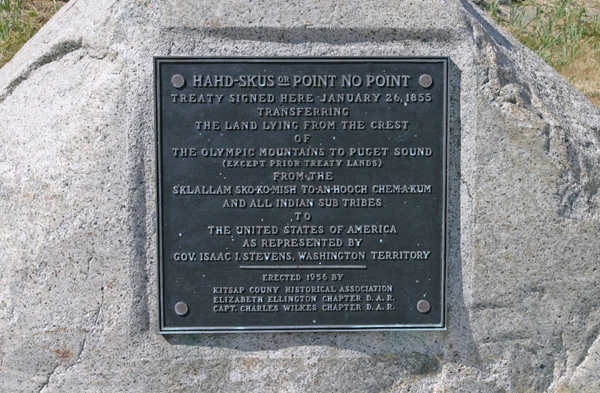
26 January 1855

The Point No Point Treaty is signed in Washington.

The Point No Point Treaty was signed on January 26, 1855 at Point No Point, on the northern tip of the Kitsap Peninsula. Governor of Washington Territory, Isaac Stevens, convened the treaty council on January 25, with the S’Klallam, the Chimakum, and the Skokomish tribes. Under the terms of the treaty, the original inhabitants of northern Kitsap Peninsula and Olympic Peninsula were to cede ownership of their land in exchange for small reservations along Hood Canal and a payment of $60,000 from the federal government. The treaty required the natives to trade only with the United States, to free all their slaves, and it abjured them not to acquire any new slaves.

On the first day of the council, treaty provisions were translated from English to the Chinook Jargon for the 1,200 natives who assembled at the sand spit they called Hadskis, across Admiralty Inlet from Whidbey Island. Today this is the site of a lighthouse.

Skokomish leader Hool-hol-tan expressed concern about finding sufficient food in the new locations, and did not like the lands being offered as a reservation. L’Hau-at-scha-uk, a To-antioch, was afraid he would die if he left his ancestral lands. Others objected that the land was being bought too cheaply, now that they understood what it was worth. The whites played down the importance of the land, but the first day ended without an agreement.

But by the next morning the various chiefs and headmen returned under white flags to add their marks to the treaty. It had already been prepared by the United States representatives in its final form; they had no true intention of negotiating over its provisions.

26 January 1855

The Point No Point Treaty is signed in Washington Territory.

The Point No Point Treaty was signed on January 26, 1855 at Point No Point, on the northern tip of the Kitsap Peninsula. Governor of Washington Territory, Isaac Stevens, convened the treaty council on January 25, with the S’Klallam, the Chimakum, and the Skokomish tribes. Under the terms of the treaty, the original inhabitants of northern Kitsap Peninsula and Olympic Peninsula were to cede ownership of their land in exchange for small reservations along Hood Canal and a payment of $60,000 from the federal government. The treaty required the natives to trade only with the United States, to free all their slaves, and it abjured them not to acquire any new slaves.

On the first day of the council, treaty provisions were translated from English to the Chinook Jargon for the 1,200 natives who assembled at the sand spit they called Hahdskus, across Admiralty Inlet from Whidbey Island. Today this is the site of a lighthouse.

Skokomish leader Hool-hol-tan expressed concern about finding sufficient food in the new locations, and did not like the lands being offered as a reservation. L’Hau-at-scha-uk, a To-anhooch, was afraid he would die if he left his ancestral lands. Others objected that the land was being bought too cheaply, now that they understood what it was worth. The whites played down the importance of the land, but the first day ended without an agreement.

But by the next morning the various chiefs and headmen returned under white flags to add their marks to the treaty. It had already been prepared by the United States representatives in its final form; they had no true intention of negotiating over its provisions.